 The Journey
 The Journey
By Kai Kasad
Last year, at a Wednesday speed session at the Burwood Athletics track, I came across a thought while warming up/cooling down with a runner friend. I mentioned that night how it would be cool to run a 50KM race (an ultra-marathon) in our 50th year, given we both reached the milestone this year. And the idea was born.
I spoke with Geoff in particular; which 50KM races were around? You see I had never run a trail event before January 2019! Which races should I run to prepare for the big event? Which brands of hydration packs are best? Which trail running event Facebook pages should I subscribe to? What were the names of the various trail running groups in and around Melbourne? I was known to have always remarked that I’d never do a trail race; that trails were just not for me. So here’s the journey I embarked upon in 2019:
- January: Two Bays Trail Run (28KM) – Mornington, VIC
- March: Duncan’s Run (23KM) – Gippsland, VIC
- June: Surf Coast Trail Marathon (42.195KM) – Surf Coast, VIC
- July: Sri Chinmoy Half-Marathon (21.1KM) – Princes Park, VIC and SCC50 recce run (28KM) – Angelsea, VIC
- August: City2Surf – Sydney, NSW and Wonderland (38KM), Grampians, Halls Gap, VIC
 Over the past 9 months, I faced the usual obstacles along the way; being time-poor, coming down with persistent chest infections at the start of autumn and end of winter; each lasting two weeks, house hunting on weekends, all of which ate into my training regime. Then with three weeks to go to the race, my knees decided they’d had enough; extreme inflammation and soreness set in. I dropped my training distance, missed yet another long run to give myself the best possible chance to get to the start line of the main event relatively pain-free.
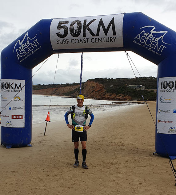
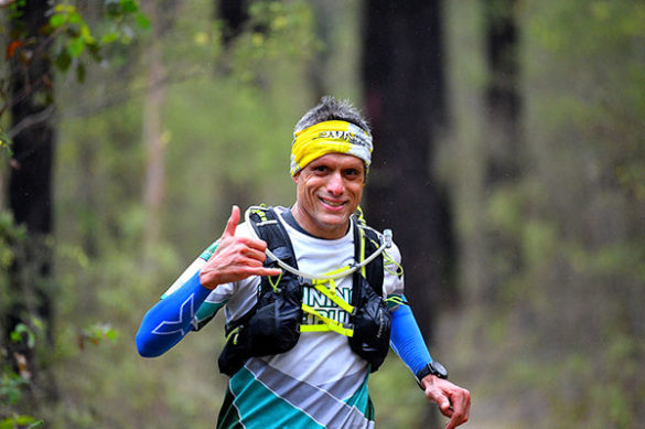
So on 23 September, I lined up to run the 50KM solo event at Surf Coast Century; an out and back route from Angelsea to Moggs Creek following an inland route, and a hillier course compared to the Surf Coast Trail Marathon which was a point-to-point race from Torquay to Fairhaven.
The Cause
I generally adopt a charity close to my heart to raise funds in running and completing these endurance runs. So when I learnt that my dear friend Kiri was diagnosed with stage 3 multiple myeloma, my choice of charity was clear – Myeloma Australia.
If you wish to donate to my cause, my fundraising page will remain open until January 2020:
 The Race
 The Race
Leg 3 was titled the toughest leg of the course but included some scenic trail running. The coast is miles away on the opposite side as we head inland but has its own charm. I had the opportunity to run this section with 125+ runners in August; a trial run of the course organised by the organisers Rapid Ascent and ably assisted by the wonderful Surf Coast Trail Runners.
Leg 3: 0km – 28km
- Distance: 28km
- Elevation gain / loss: 760m / 720m
- Terrain style: A mixture of 2WD, 4WD and single tracks through more remote sections of the coastal bushland (with extensive wildflowers all around). This is the hilliest leg of the race and the crux of the course.
- Leg start point: CP4 at Anglesea Lions Park, Great Ocean Road
- Leg finish point: CP6 at Tallawalla Guide Camp, Boyd Ave, Moggs Creek
- Cut off (all runners must depart by): 10:30pm at CP6.
The 50KM racers had a mass start on the beach at Angelsea but not before walking 1KM to the start from the event centre at Angelsea green. Nice little warm up. We ran down the beach under the start sign and turned around to once again run back towards the arch before heading down the right hand side of the river on a wide gravel path and then over the Great Ocean Road to continue along the gravel path across the road.
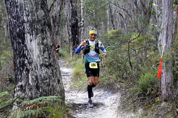
The course took us across a couple of foot bridges and then along a single track, followed by a gravel 2WD road uphill section. This was one of the first big climbs of the course as we tackled a heart-pounding climb up ‘Heartbreak Hill’ to the top of Mt. Ingoldsby; this was just the 5km point! From here we continued on to a red clay 4WD track that provided seemingly endless views inland across the Anglesea Heath to the north – but what was also the most difficult part of the course with long and steep rolling hills.
 We did a steep descent down the clay 4WD track which was muddy given the recent wet weather and my shoes started to get heavier with the clay which had collected very quickly on my soles. I stopped from time to time to shake off the mud as we then tackled the next decent climb of the day out the other side for another rather “epic hill”. Once we had conquered this incline we veered onto a single track amongst wild flowers; what stage of the race were we at after all of this? 10KM done of 50km and the first of the aid stations along the course; although this was unmanned and only had water tanks.
I looked at my watch which read 11.54KMs – I couldn’t work out how I had run an extra 1.5 kms; another runner confirmed the time and we agreed: that’s trail running for you! The track descended to what is deemed arguably the best trail running loop in the Otways – a flowing single track that climbs gradually up the valley past Currawong Falls to a trig point on the ridge (18km pt).
This section between 12Km and 18KM was not my friend. My knees had quickly become inflamed with the inclines and declines up until now and I was having a mental battle as to how I would complete the remainder of the race. This thought, I remember quite distinctly, was at the 14Km mark as I contemplated the remaining 36km! I used my own advice (you can deal with things that are in your control). Knowing there was no quick fix for the issue and there was nothing I could do to get rid of the knee soreness, I tried my best to put it out of my mind and concentrated on breathing into the area of discomfort – a technique I use in my mindfulness meditation practice.
So, one foot in front of the other I went; knowing that each step was getting me closer to my destination. We still had another 10KM to go to the first of two major check points of our race. As we finish the single track and cross the dirt road we arrive at CP5 (21km pt) at the Distillery Creek Picnic Ground and the ‘intermediary race kitchen’ for some nourishment.
I grab a piece of fruit cake and some crisps, fill my water bladder and head off again. My spirits have now lifted a bit by the cheering spectators and sustenance.
We continue through a picnic area along a single track which becomes a 2WD dirt road for about 2km; we cross the Painkalac Reservoir wall after which the course turns skyward for the final ascent of Leg 3 as we wind our way up a dirt 4WD track. This is the 26km pt. I’d like to say that I enjoyed the long descent down a similar 4WD track to the end of Leg 3 at CP6 at Tallawalla Guide Camps at Moggs Creek, but in reality I *hate* steep downhills! However, this section of the race begins to feel familiar having done a recce run a few weeks before and I know I am close to the full ‘Race Kitchen’ which is a welcome sight.
CP6 is a hive of activity! Runners are applauded along the 100m or so path leading into the clearing and then I find I am trying to:
- find my spare bag (which I elected to have at the CP in the event of the rain which was forecast);
- have some real food (mashed potato!);
- throw a couple of energy bars into my backpack,
- fill my water bladder and
- still trying to find my bag!
I finally spot my kit and see Jody who kindly offers to fill up the spare bottle with electrolyte powder that I had stowed in my spare kit bag. I refill my soft flasks and finally exit the CP. In my hectic state of mind, I forget to use the toilets! My calves have started to indicate the onset of cramps so I stretch them out from time to time.
Note to self: I really need to experiment with pickle juice and salt tablets as this is the second instance (the first being the Surf Coast Trail Marathon) that I felt twinges in my calves; luckily that day I was saved by a fellow runner who offered me a couple of salt tablets. Today would be a bit touch and go.
Leg 4: 28km – 50km
- Distance: 22km
- Elevation gain / loss: 426m / 466m
- Terrain style: Another mixture of 2WD, 4WD tracks and single track that returns us to the beach for a stint along the sand to the finish line; a hilly start but a flat finish.
- Leg start point: CP6 at Tallawalla Guide Camp, Moggs Creek
- Leg finish point: The finish line at Anglesea Green, Great Ocean Road
After leaving CP6 at Moggs Creek we follow yet more single track through tall timber forest to finally come to the point of the course where that we turn towards Anglesea and head for the finish. We cross a quaint footbridge around the 31Km mark; quite bouncy when you have more than one runner crossing it!
A few more sandy undulating kms later I hear vehicles and see the great ocean road which means we will soon be done with the inland section and will now run the remainder of the race along the coastline; the bit I am reasonably familiar with having run the Surf Coast Trail Marathon in end-Jun…but not completely familiar! Here, we are required to go under the low bridge (on hands and nearly knees). As I come out on the other side I am asked by a volunteer how that felt. My honest answer was it was easier than the downhills! We run the few hundred metres along the Great Ocean Road towards CP7 at Aireys Inlet and the ‘intermediary race kitchen’ at the Aireys Inlet Skate Park (37km pt).
First things first; I use the toilet! I then exchange pleasantries with a runner I’d met when I did a training run with the Dandenong Trail Runners. I grab a piece of fruit cake, some crisps, throw back a couple of cups of Coke, stash a couple of energy bars into my pack and proceed to have my water bladder filled; little did I know.
We follow the gravel footpath out of CP7 and it soon winds uphill to the majestic Aireys Inlet Lighthouse. I touch the lighthouse spontaneously (later realized it was almost the expected thing to do!) and run along the along the cliff tops with views of the sea for kilometres! I stop here to pull out my phone to go live so that family and friends can track my progress. I intentionally hadn’t switched it on for fear of draining my phone’s battery (as forewarned). So many logistics to think about so I had to get something wrong! I later realized why I couldn’t be tracked (as I communicated via WhatsApp along the way).. I had given the correct race app to family but didn’t open the right app myself!
I have been consistently sipping water all the way. To my surprise I find I have now run out of water! Clearly I had overestimated the bladder refill at Aireys Inlet! With no more aid stations now until the finish I need to ration my remaining fluids; the bits remaining in my soft flasks.
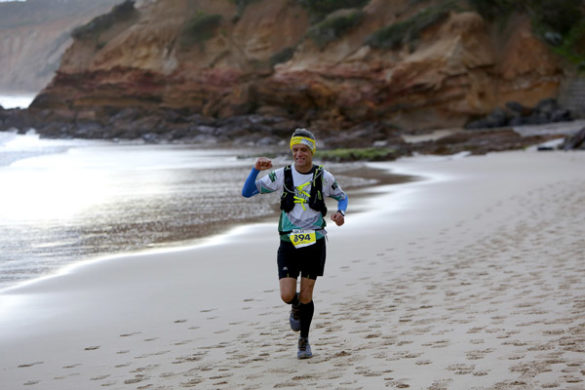
We take the stairs down to Sunnymeade Beach (40km pt) and continue along the beach for just 150m before we climb up another set of stairs and follow the trail once again as it winds through the bushland, eventually descending again at Urquhart’s Beach (46Km). Then follows the longest stretch along the beach; as I put one foot in front of the other for the next 3.4km to Anglesea. The tide is low but the sand is not as firm as I’d encountered on the past two occasions.
I vary my running path between damp (seemingly flat) and dry (divots caused by earlier feet) sand but find that the latter is a little better even if the sand is uneven. My calves are really being tested along this 3.5 km patch and luckily for me my ration of electrolytes is still fairly adequate and seem to keep the cramps at bay.
Residents walking along the beach clap and compliment us as we run past. It really puts all those demons in my mind 14KM in, in perspective when I think what they might be thinking; on the outside looking in; in awe or wondrous puzzlement of our crazy feat! Why? Some may be pondering.
We remain on the beach until we get to the first set of large timber stairs and a sign indicating where we leave the beach. We climb up stairs with a set of 50 or so steps and then re-join the gravel Surf Coast Walk again at Point Roadknight as it climbs up to a lookout and then descends to the Anglesea Surf Life Saving Club. We make our final descent onto Anglesea Main Beach for some more sand running and finally leave the river mouth towards THE FINISH LINE in the parkland adjacent to the river. With 1.5Km to go, I realize I have already well and truly run 50+KMS!
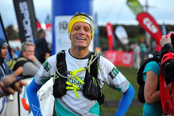
I see spectators at the far end of the Surf Coast Walk mud path that leads off the river mouth towards Angelsea Green and can now hear people sounds and music.I know I am not far away and my heart starts to pound with excitement! As I get commendation from yet more spectators I let another runner overtake me (I can never understand this last dash to the finish line!). I want the finish to be my own.
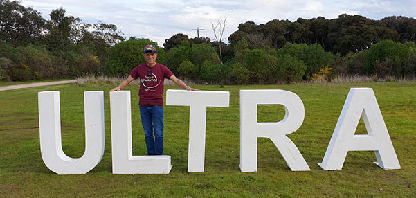
As I run around the corner I see the finish chute and as I run past the big ULTRA sign, I give it a peck! I am on my own with nobody ahead or behind me and I can really enjoy this moment I have been planning, training, dreaming and visualising about for more than 9 months!
I hear someone call out my name and there she is: my groupie and my biggest fan, who has driven from Melbourne to Angelsea just to see me complete this milestone and witness me achieve my dream. I run across to kiss her and cross the finish line even managing the trail runner’s signature jump right on the finish line.
I am asked by a volunteer if I am okay. I inform her, that I am. “Tears of joy?” she inquires. “Tears of joy” I reply. “It’s been a long road to this moment” I add. “Well done” she says. “That’s an awesome achievement”.
I am over the moon.
I have done it.
I AM AN ULTRAMARATHONER!

Credits: the course descriptions have been paraphrased from the event’s website at:
https://surfcoastcentury.rapidascent.com.au/event-details/the-race/course-descriptions/